Topic 1.1: South Carolina Geography
Continents, Countries, and States
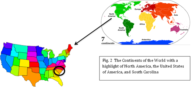
Before we begin looking at the geography of South Carolina, let's take a look at the location of South Carolina with relation to the rest of the world. South Carolina is located on the continent of North America, which is located in the western hemisphere. To go farther, South Carolina is a state in the United States of America, a country in North America.
Specifically South Carolina
Now to focus on South Carolina specifically, we are going to examine the different geographical features of South Carolina. Let’s begin by looking at the landform regions of South Carolina.
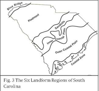
South Carolina is comprised of six landform regions: Coastal Zone, Outer Coastal Plain, Inner Coastal Plain, Sandhills, Piedmont, and Blue Ridge. The Coastal Zone is only a few feet above sea level and it most known for its beaches, especially Myrtle Beach. The Outer Coastal Plain was the primary location of most rice and indigo plantations. The Inner Coastal Plain had the richest farm land and is most notable for its cotton plantations. Together, the Outer Coastal Plain and Inner Coastal Plain are known as the Coastal Plains, the largest landform region in South Carolina. Directly above the Coastal Plains are the Sandhills. The Sandhills are a region that extends along the fall zone. This region, many, many years ago, was once the coastline. Whereas the Coastal Plains are notable for their plantations, the Sandhills are known for its pine forests and fruit orchards. Next we have the Piedmont.
The Piedmont region contains about one-third of South Carolina's land mass. Its rivers and streams are narrow and swift due to the increased elevation of its many hills. The Piedmont region has hills because it is directly below the Blue Ridge region. As you may have already guessed, the Blue Ridge region is the mountainous region of South Carolina. The highest peak in South Carolina is the Sassafras Mountain which is a huge tourist attraction. Those are the six landform regions that are found in South Carolina.
Now to focus on South Carolina specifically, we are going to examine the different geographical features of South Carolina. Let’s begin by looking at the landform regions of South Carolina.
South Carolina is comprised of six landform regions: Coastal Zone, Outer Coastal Plain, Inner Coastal Plain, Sandhills, Piedmont, and Blue Ridge. The Coastal Zone is only a few feet above sea level and it most known for its beaches, especially Myrtle Beach. The Outer Coastal Plain was the primary location of most rice and indigo plantations. The Inner Coastal Plain had the richest farm land and is most notable for its cotton plantations. Together, the Outer Coastal Plain and Inner Coastal Plain are known as the Coastal Plains, the largest landform region in South Carolina. Directly above the Coastal Plains are the Sandhills. The Sandhills are a region that extends along the fall zone. This region, many, many years ago, was once the coastline. Whereas the Coastal Plains are notable for their plantations, the Sandhills are known for its pine forests and fruit orchards. Next we have the Piedmont.
The Piedmont region contains about one-third of South Carolina's land mass. Its rivers and streams are narrow and swift due to the increased elevation of its many hills. The Piedmont region has hills because it is directly below the Blue Ridge region. As you may have already guessed, the Blue Ridge region is the mountainous region of South Carolina. The highest peak in South Carolina is the Sassafras Mountain which is a huge tourist attraction. Those are the six landform regions that are found in South Carolina.
Content information was
obtained from the South Carolina state standards support document for eighth
grade Social Studies. This document can
be located at
http://www.ed.sc.gov/agency/se/Instructional-Practices-and-Evaluations/documents/Grade8SupportDocument.pdf
.All images were obtained from
Google.com and were labeled as Free to Use or Share.
